
Lakefront Estates · Parcel explorer
A closer look.
Lot by lot.
Explore the land, follow the records, and see where each property fits. Select a parcel to open its details.
Boundaries: Jul 9, 2026
Permit observations: Nov 1, 2026 · Listings: Oct 7, 2026
Developer inventory: Oct 11, 2026
Swipe to scroll · Tap a parcel
Map layers
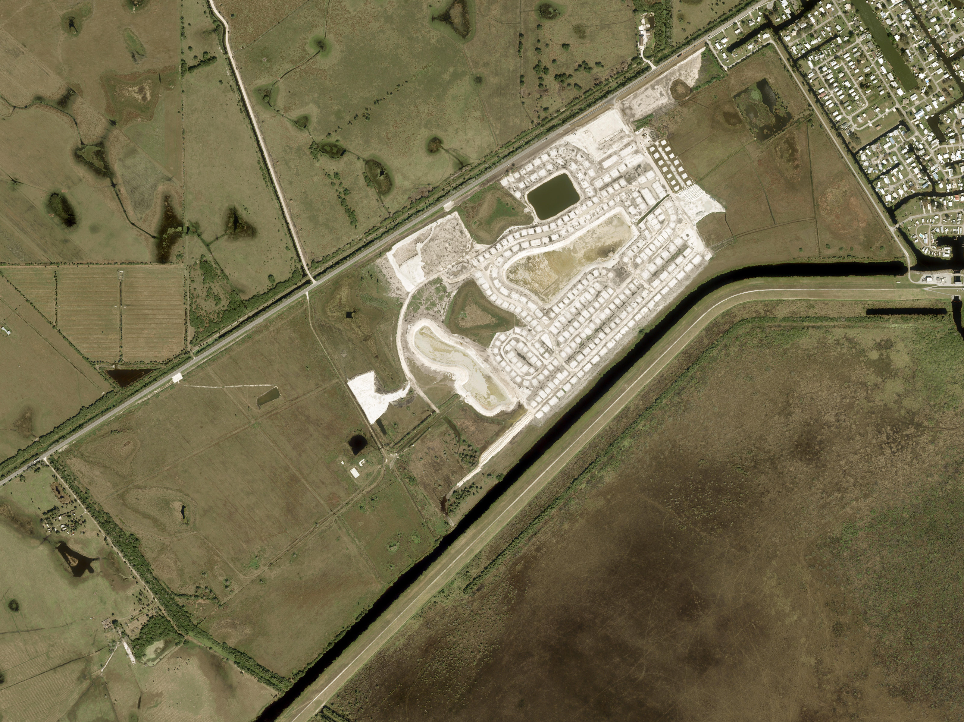
Satellite imagery
258 numbered lots · 49 other parcels
Drag to pan · Use + / − or pinch to zoom
Choose a street to find it on the map, or zoom in for more names. Street names, Phase 1 & the wine connection →
Gold: Lakefront’s recorded plat, including future-development tracts. Blue dashed: Phase 1A assessment area. Fine gray dashed: approximate planning phases 1–4. Boundary sources.
Permit inspection histories retain their October 8 capture date; CO and parcel observations were reviewed November 1. Property status highlights recorded closings alongside permit milestones. A closed sale does not establish occupancy approval. Tax-map boundaries are not a survey. Colors reflect dated records and developer observations, not live construction progress or availability. The illustrated plan shows proposed features; it does not establish what is built. A blank record does not mean a property is available.
Imagery: Esri, Vantor, Earthstar Geographics, and the GIS User Community. Capture date not established. Map sources & dates ↓
Browse parcels as a list 307 parcel records
No parcels match these filters. Try an address, a block and lot, or clear the filters.
- Block 1 · Lot 1S34-38-34-001-0001-0010Status unknown
- Block 1 · Lot 2S34-38-34-001-0001-0020Status unknown
- Block 1 · Lot 3S34-38-34-001-0001-0030Status unknown
- Block 1 · Lot 4S34-38-34-001-0001-0040Status unknown
- Block 1 · Lot 5S34-38-34-001-0001-0050Status unknown
- 1110 CHEVRON DRIVEBlock 1 · Lot 6Status unknown
- Block 1 · Lot 7S34-38-34-001-0001-0070Status unknown
- Block 1 · Lot 8S34-38-34-001-0001-0080Status unknown
- 1140 CHEVRON DRBlock 1 · Lot 9Permit issued
- 1150 CHEVRON DRBlock 1 · Lot 10Permit issued
- 1160 CHEVRON DRBlock 1 · Lot 11Status unknown
- 1170 CHEVRON DRBlock 1 · Lot 12Permit issued
- 1180 CHEVRON DRBlock 1 · Lot 13Permit issued
- Block 1 · Lot 14S34-38-34-001-0001-0140Permit issued
- 1200 CHEVRON DRBlock 1 · Lot 15Permit issued
- 1212 CHEVRON DRBlock 1 · Lot 16Permit issued
- 1226 CHEVRON DRBlock 1 · Lot 17Permit issued
- 1236 CHEVRON DRBlock 1 · Lot 18Permit issued
- 1248 CHEVRON DRBlock 1 · Lot 19Permit issued
- 1260 CHEVRON DRBlock 1 · Lot 20Permit issued
- Block 1 · Lot 21S34-38-34-001-0001-0210Permit issued
- Block 1 · Lot 22S34-38-34-001-0001-0220Permit issued
- Block 1 · Lot 23S34-38-34-001-0001-0230Permit issued
- Block 1 · Lot 24S34-38-34-001-0001-0240Permit issued
- Block 2 · Lot 1S34-38-34-001-0002-0010Status unknown
- 2023 TURA CTBlock 2 · Lot 2CO documented
- 2027 TURA CTBlock 2 · Lot 3CO documented
- 2033 TURA CTBlock 2 · Lot 4CO documented
- 2037 TURA CTBlock 2 · Lot 5CO documented
- 2043 TURA CTBlock 2 · Lot 6CO documented
- 2047 TURA CTBlock 2 · Lot 7CO documented
- 2053 TURA CTBlock 2 · Lot 8CO documented
- 2055 TURA CTBlock 2 · Lot 9CO documented
- 1782 RASHI DRBlock 2 · Lot 10CO documented
- 1772 RASHI DRBlock 2 · Lot 11CO documented
- 1762 RASHI DRBlock 2 · Lot 12CO documented
- 1752 RASHI DRIVEBlock 2 · Lot 13CO documented
- 1724 RASHI DRBlock 2 · Lot 14CO documented
- 1712 RASHI DRIVEBlock 2 · Lot 15CO documented
- 27182 E STATE RDBlock 3 · Lot 1Permit issued
- Block 3 · Lot 2S34-38-34-001-0003-0020Permit issued
- Block 3 · Lot 3S34-38-34-001-0003-0030Permit issued
- Block 3 · Lot 4S34-38-34-001-0003-0040Status unknown
- Block 3 · Lot 5S34-38-34-001-0003-0050Permit issued
- 1383 ALFASI DRBlock 3 · Lot 6Permit issued
- Block 3 · Lot 7S34-38-34-001-0003-0070Permit issued
- Block 3 · Lot 8S34-38-34-001-0003-0080Permit issued
- 1409 ALFASI DRBlock 3 · Lot 9Permit issued
- 1421 ALFASI DRBlock 3 · Lot 10Permit issued
- Block 3 · Lot 11S34-38-34-001-0003-0110Permit issued
- Block 3 · Lot 12S34-38-34-001-0003-0120Permit issued
- Block 3 · Lot 13S34-38-34-001-0003-0130Permit issued
- 1451 ALFASI DRBlock 3 · Lot 14CO documented
- 1457 ALFASI DRBlock 3 · Lot 15CO documented
- 1463 ALFASI DRIVEBlock 3 · Lot 16CO documented
- Block 4 · Lot 1S34-38-34-001-0004-0010Permit issued
- Block 4 · Lot 2S34-38-34-001-0004-0020Permit issued
- Block 4 · Lot 3S34-38-34-001-0004-0030Permit issued
- Block 4 · Lot 4S34-38-34-001-0004-0040Permit issued
- 1370 ALFASI DRIVEBlock 4 · Lot 5CO documented
- 1382 ALFASI DRIVEBlock 4 · Lot 6CO documented
- 1415 BINYAMINA PLACEBlock 4 · Lot 7CO documented
- Block 4 · Lot 8S34-38-34-001-0004-0080Permit issued
- Block 4 · Lot 9S34-38-34-001-0004-0090Permit issued
- Block 4 · Lot 10S34-38-34-001-0004-0100Permit issued
- Block 4 · Lot 11S34-38-34-001-0004-0110Permit issued
- Block 4 · Lot 12S34-38-34-001-0004-0120Permit issued
- 1341 BINYAMINA PLACEBlock 4 · Lot 13CO documented
- 1317 CHEVRON DRIVEBlock 5 · Lot 1CO documented
- Block 5 · Lot 2S34-38-34-001-0005-0020Permit issued
- Block 5 · Lot 3S34-38-34-001-0005-0030Permit issued
- 1265 CHEVRON DRBlock 5 · Lot 4Permit issued
- 1253 CHEVRON DRBlock 5 · Lot 5Permit issued
- 1239 Chevron DriveBlock 5 · Lot 6Status unknown
- 1229 Chevron DriveBlock 5 · Lot 7Status unknown
- Block 5 · Lot 8S34-38-34-001-0005-0080Status unknown
- Block 5 · Lot 9S34-38-34-001-0005-0090Status unknown
- 1183 CHEVRON DRBlock 5 · Lot 10Permit issued
- Block 5 · Lot 11S34-38-34-001-0005-0110Permit issued
- Block 5 · Lot 12S34-38-34-001-0005-0120Permit issued
- Block 5 · Lot 13S34-38-34-001-0005-0130Permit issued
- Block 5 · Lot 14S34-38-34-001-0005-0140Status unknown
- 1081 CHEVRON DRBlock 5 · Lot 15CO documented
- 1069 CHEVRON DRIVEBlock 5 · Lot 16CO documented
- 1059 CHEVRON DRBlock 5 · Lot 17CO documented
- 1045 CHEVRON DRBlock 5 · Lot 18CO documented
- 1037 CHEVRON DRIVEBlock 5 · Lot 19CO documented
- 1798 RASHI DRIVEBlock 5 · Lot 20CO documented
- 1808 RASHI DRBlock 5 · Lot 21CO documented
- 1818 RASHI DRBlock 5 · Lot 22CO documented
- 1828 RASHI DRBlock 5 · Lot 23CO documented
- 1838 RASHI DRBlock 5 · Lot 24CO documented
- 1848 RASHI DRBlock 5 · Lot 25CO documented
- 1860 RASHI DRBlock 5 · Lot 26CO documented
- 1870 RASHI DR.Block 5 · Lot 27CO documented
- 1882 RASHI DRBlock 5 · Lot 28CO documented
- 1894 RASHI DR.Block 5 · Lot 29CO documented
- 1906 Rashi DriveBlock 5 · Lot 30CO documented
- 1914 RASHI DRBlock 5 · Lot 31CO documented
- 1924 Rashi DriveBlock 5 · Lot 32CO documented
- 1934 RASHI DRBlock 5 · Lot 33CO documented
- 1944 RASHI DRBlock 5 · Lot 34CO documented
- 1952 RASHI DRBlock 5 · Lot 35CO documented
- 1964 RASHI DRBlock 5 · Lot 36CO documented
- 1974 RASHI DRIVEBlock 5 · Lot 37CO documented
- 1984 RASHI DRBlock 5 · Lot 38CO documented
- 1994 RASHI DRBlock 5 · Lot 39CO documented
- Block 6 · Lot 1S34-38-34-001-0006-0010Permit issued
- 1464 Alfasi DriveBlock 6 · Lot 2Closed · recorded deed
- 1456 ALFASI DRIVEBlock 6 · Lot 3CO documented
- Block 6 · Lot 4S34-38-34-001-0006-0040Permit issued
- 1414 BINYAMINA PLACEBlock 6 · Lot 5CO documented
- 1396 BINYAMINA PLACEBlock 6 · Lot 6CO documented
- 1380 Binyamina Pl.Block 6 · Lot 7CO documented
- Block 6 · Lot 8S34-38-34-001-0006-0080Permit issued
- Block 6 · Lot 9S34-38-34-001-0006-0090Permit issued
- 1763 Rashi DriveBlock 6 · Lot 10CO documented
- 1773 RASHI DRBlock 6 · Lot 11CO documented
- 1781 RASHI DRIVEBlock 6 · Lot 12CO documented
- 1793 RASHI DRBlock 6 · Lot 13CO documented
- 1801 RASHI DRIVEBlock 6 · Lot 14CO documented
- 1811 RASHI DRIVEBlock 6 · Lot 15CO documented
- 1821 Rashi DriveBlock 6 · Lot 16CO documented
- 1833 Rashi DrBlock 6 · Lot 17CO documented
- 1841 RASHI DRBlock 6 · Lot 18CO documented
- 1851 RASHI DRBlock 6 · Lot 19CO documented
- 1863 RASHI DRBlock 6 · Lot 20CO documented
- 1875 RASHI DRBlock 6 · Lot 21CO documented
- 1889 Rashi Drive SBlock 6 · Lot 22CO documented
- Block 6 · Lot 23S34-38-34-001-0006-0230Status unknown
- 1919 RASHI DRIVEBlock 6 · Lot 24CO documented
- 1935 RASHI DRIVEBlock 6 · Lot 25CO documented
- 1949 RASHI DRBlock 6 · Lot 26CO documented
- Block 6 · Lot 27S34-38-34-001-0006-0270Status unknown
- Block 6 · Lot 28S34-38-34-001-0006-0280Permit issued
- Block 6 · Lot 29S34-38-34-001-0006-0290Permit issued
- Block 6 · Lot 30S34-38-34-001-0006-0300Permit issued
- 1389 Herzog DriveBlock 6 · Lot 31CO documented
- Block 6 · Lot 32S34-38-34-001-0006-0320Status unknown
- Block 6 · Lot 33S34-38-34-001-0006-0330Permit issued
- Block 6 · Lot 34S34-38-34-001-0006-0340Status unknown
- Block 6 · Lot 35S34-38-34-001-0006-0350Status unknown
- 1883 Sforno RoadBlock 6 · Lot 36CO documented
- 27182 E STATE RDBlock 6 · Lot 37Permit issued
- 1895 SFORNO ROADBlock 6 · Lot 38CO documented
- 27182 E STATE RDBlock 6 · Lot 39Permit issued
- 1907 SFORNO RDBlock 6 · Lot 40CO documented
- 1913 SFORNO RDBlock 6 · Lot 41CO documented
- 1919 SFORNO RDBlock 6 · Lot 42CO documented
- 1925 SFRONO DRIVEBlock 6 · Lot 43CO documented
- 1933 SFORNO RDBlock 6 · Lot 44CO documented
- 1937 SFORNO DRIVEBlock 6 · Lot 45CO documented
- 27182 E STATE RDBlock 6 · Lot 46Permit issued
- 1947 SFORNO DRIVEBlock 6 · Lot 47CO documented
- Block 7 · Lot 1S34-38-34-001-0007-0010Permit completed
- 1338 HERZOG DRIVEBlock 7 · Lot 2CO documented
- Block 7 · Lot 3S34-38-34-001-0007-0030Permit issued
- Block 7 · Lot 4S34-38-34-001-0007-0040Permit issued
- Block 7 · Lot 5S34-38-34-001-0007-0050Permit issued
- Block 7 · Lot 6S34-38-34-001-0007-0060Status unknown
- 1380 HERZOG DRBlock 7 · Lot 7CO documented
- 1390 Herzog Dr.Block 7 · Lot 8CO documented
- 1400 Herzog DrBlock 7 · Lot 9Permit issued
- 1412 Herzog DrBlock 7 · Lot 10Permit issued
- 1422 Herzog DrBlock 7 · Lot 11Permit issued
- 1432 Herzog DrBlock 7 · Lot 12Permit issued
- Block 7 · Lot 13S34-38-34-001-0007-0130Status unknown
- Block 8 · Lot 1S34-38-34-001-0008-0010Status unknown
- Block 8 · Lot 2S34-38-34-001-0008-0020Permit issued
- Block 8 · Lot 3S34-38-34-001-0008-0030Permit issued
- Block 8 · Lot 4S34-38-34-001-0008-0040Permit issued
- 1904 Sforno RoadBlock 8 · Lot 5Permit issued
- Block 8 · Lot 6S34-38-34-001-0008-0060Permit issued
- Block 8 · Lot 7S34-38-34-001-0008-0070Permit issued
- Block 8 · Lot 8S34-38-34-001-0008-0080Permit issued
- Block 8 · Lot 9S34-38-34-001-0008-0090Permit issued
- 1872 SFORNO RDBlock 8 · Lot 10Permit completed
- Block 9 · Lot 1S34-38-34-001-0009-0010Status unknownNo matched property record
- Block 9 · Lot 2S34-38-34-001-0009-0020Status unknownNo matched property record
- Block 9 · Lot 3S34-38-34-001-0009-0030Status unknownNo matched property record
- Block 9 · Lot 4S34-38-34-001-0009-0040Status unknownNo matched property record
- Block 9 · Lot 5S34-38-34-001-0009-0050Status unknownNo matched property record
- Block 9 · Lot 6S34-38-34-001-0009-0060Status unknownNo matched property record
- Block 9 · Lot 7S34-38-34-001-0009-0070Status unknownNo matched property record
- Block 9 · Lot 8S34-38-34-001-0009-0080Status unknownNo matched property record
- Block 9 · Lot 9S34-38-34-001-0009-0090Status unknownNo matched property record
- Block 9 · Lot 10S34-38-34-001-0009-0100Status unknownNo matched property record
- Block 9 · Lot 11S34-38-34-001-0009-0110Status unknownNo matched property record
- Block 9 · Lot 12S34-38-34-001-0009-0120Status unknownNo matched property record
- Block 9 · Lot 13S34-38-34-001-0009-0130Status unknownNo matched property record
- Block 10 · Lot 1S34-38-34-001-0010-0010Status unknownNo matched property record
- Block 10 · Lot 2S34-38-34-001-0010-0020Status unknownNo matched property record
- Block 10 · Lot 3S34-38-34-001-0010-0030Status unknownNo matched property record
- Block 10 · Lot 4S34-38-34-001-0010-0040Status unknownNo matched property record
- Block 10 · Lot 5S34-38-34-001-0010-0050Status unknownNo matched property record
- Block 10 · Lot 6S34-38-34-001-0010-0060Status unknownNo matched property record
- Block 10 · Lot 7S34-38-34-001-0010-0070Status unknownNo matched property record
- Block 10 · Lot 8S34-38-34-001-0010-0080Status unknownNo matched property record
- Block 10 · Lot 9S34-38-34-001-0010-0090Status unknownNo matched property record
- Block 10 · Lot 10S34-38-34-001-0010-0100Status unknownNo matched property record
- Block 10 · Lot 11S34-38-34-001-0010-0110Status unknownNo matched property record
- Block 10 · Lot 12S34-38-34-001-0010-0120Status unknownNo matched property record
- Block 10 · Lot 13S34-38-34-001-0010-0130Status unknownNo matched property record
- Block 10 · Lot 14S34-38-34-001-0010-0140Status unknownNo matched property record
- Block 10 · Lot 15S34-38-34-001-0010-0150Status unknownNo matched property record
- Block 10 · Lot 16S34-38-34-001-0010-0160Status unknownNo matched property record
- Block 10 · Lot 17S34-38-34-001-0010-0170Status unknownNo matched property record
- Block 10 · Lot 18S34-38-34-001-0010-0180Status unknownNo matched property record
- Block 10 · Lot 19S34-38-34-001-0010-0190Status unknownNo matched property record
- Block 10 · Lot 20S34-38-34-001-0010-0200Status unknownNo matched property record
- Block 11 · Lot 1S34-38-34-001-0011-0010Status unknownNo matched property record
- Block 11 · Lot 2S34-38-34-001-0011-0020Status unknownNo matched property record
- Block 11 · Lot 3S34-38-34-001-0011-0030Status unknownNo matched property record
- Block 11 · Lot 4S34-38-34-001-0011-0040Status unknownNo matched property record
- Block 11 · Lot 5S34-38-34-001-0011-0050Status unknownNo matched property record
- Block 11 · Lot 6S34-38-34-001-0011-0060Status unknownNo matched property record
- Block 11 · Lot 7S34-38-34-001-0011-0070Status unknownNo matched property record
- Block 11 · Lot 8S34-38-34-001-0011-0080Status unknownNo matched property record
- Block 11 · Lot 9S34-38-34-001-0011-0090Status unknownNo matched property record
- Block 12 · Lot 1S34-38-34-001-0012-0010Status unknownNo matched property record
- Block 12 · Lot 2S34-38-34-001-0012-0020Status unknownNo matched property record
- Block 13 · Lot 1S34-38-34-001-0013-0010Status unknownNo matched property record
- Block 13 · Lot 2S34-38-34-001-0013-0020Status unknownNo matched property record
- Block 13 · Lot 3S34-38-34-001-0013-0030Status unknownNo matched property record
- Block 13 · Lot 4S34-38-34-001-0013-0040Status unknownNo matched property record
- Block 13 · Lot 5S34-38-34-001-0013-0050Status unknownNo matched property record
- Block 13 · Lot 6S34-38-34-001-0013-0060Status unknownNo matched property record
- Block 13 · Lot 7S34-38-34-001-0013-0070Status unknownNo matched property record
- Block 13 · Lot 8S34-38-34-001-0013-0080Status unknownNo matched property record
- Block 13 · Lot 9S34-38-34-001-0013-0090Status unknownNo matched property record
- Block 13 · Lot 10S34-38-34-001-0013-0100Status unknownNo matched property record
- Block 14 · Lot 1S34-38-34-001-0014-0010Status unknownNo matched property record
- Block 14 · Lot 2S34-38-34-001-0014-0020Status unknownNo matched property record
- Block 14 · Lot 3S34-38-34-001-0014-0030Status unknownNo matched property record
- Block 15 · Lot 1S34-38-34-001-0015-0010Status unknownNo matched property record
- Block 15 · Lot 2S34-38-34-001-0015-0020Status unknownNo matched property record
- Block 15 · Lot 3S34-38-34-001-0015-0030Status unknownNo matched property record
- Block 15 · Lot 4S34-38-34-001-0015-0040Status unknownNo matched property record
- Block 15 · Lot 5S34-38-34-001-0015-0050Status unknownNo matched property record
- Block 15 · Lot 6S34-38-34-001-0015-0060Status unknownNo matched property record
- Block 15 · Lot 7S34-38-34-001-0015-0070Status unknownNo matched property record
- Block 15 · Lot 8S34-38-34-001-0015-0080Status unknownNo matched property record
- Block 15 · Lot 9S34-38-34-001-0015-0090Status unknownNo matched property record
- Block 15 · Lot 10S34-38-34-001-0015-0100Status unknownNo matched property record
- Block 15 · Lot 12S34-38-34-001-0015-0120Status unknownNo matched property record
- Block 15 · Lot 13S34-38-34-001-0015-0130Status unknownNo matched property record
- Block 15 · Lot 14S34-38-34-001-0015-0140Status unknownNo matched property record
- Block 15 · Lot 15S34-38-34-001-0015-0150Status unknownNo matched property record
- Block 16 · Lot 1S34-38-34-001-0016-0010Status unknownNo matched property record
- Block 16 · Lot 2S34-38-34-001-0016-0020Status unknownNo matched property record
- Block 16 · Lot 3S34-38-34-001-0016-0030Status unknownNo matched property record
- Block 16 · Lot 4S34-38-34-001-0016-0040Status unknownNo matched property record
- Block 16 · Lot 5S34-38-34-001-0016-0050Status unknownNo matched property record
- Block 16 · Lot 6S34-38-34-001-0016-0060Status unknownNo matched property record
- Block 16 · Lot 7S34-38-34-001-0016-0070Status unknownNo matched property record
- Block 17 · Lot 1S34-38-34-001-0017-0010Status unknownNo matched property record
- Block 17 · Lot 2S34-38-34-001-0017-0020Status unknownNo matched property record
- Block 17 · Lot 3S34-38-34-001-0017-0030Status unknownNo matched property record
- Tract CE05S34-38-34-001-0000-CE05Status unknownNo matched property record
- Tract CE06S34-38-34-001-0000-CE06Status unknownNo matched property record
- Tract CE07S34-38-34-001-0000-CE07Status unknownNo matched property record
- Tract CE08S34-38-34-001-0000-CE08Status unknownNo matched property record
- Tract CE09S34-38-34-001-0000-CE09Status unknownNo matched property record
- Tract CE10S34-38-34-001-0000-CE10Status unknownNo matched property record
- Tract CE12S34-38-34-001-0000-CE12Status unknownNo matched property record
- Tract CE15S34-38-34-001-0000-CE15Status unknownNo matched property record
- 1463 Rambam BlvdTract CH01Status unknown
- Tract CS01S34-38-34-001-0000-CS01Status unknownNo matched property record
- Tract CS02S34-38-34-001-0000-CS02Status unknownNo matched property record
- Tract CT02S34-38-34-001-0000-CT02Status unknownNo matched property record
- Tract CT03S34-38-34-001-0000-CT03Status unknownNo matched property record
- Tract DT01S34-38-34-001-0000-DT01Status unknownNo matched property record
- Tract GA01S34-38-34-001-0000-GA01Status unknownNo matched property record
- Tract GA02S34-38-34-001-0000-GA02Status unknownNo matched property record
- Tract GA03S34-38-34-001-0000-GA03Status unknownNo matched property record
- Tract GA04S34-38-34-001-0000-GA04Status unknownNo matched property record
- Tract GA05S34-38-34-001-0000-GA05Status unknownNo matched property record
- Tract GA06S34-38-34-001-0000-GA06Status unknownNo matched property record
- Tract GA07S34-38-34-001-0000-GA07Status unknownNo matched property record
- Tract OS01S34-38-34-001-0000-OS01Status unknownNo matched property record
- Tract OS02S34-38-34-001-0000-OS02Status unknownNo matched property record
- Tract OS03S34-38-34-001-0000-OS03Status unknownNo matched property record
- Tract OS04S34-38-34-001-0000-OS04Status unknownNo matched property record
- Tract PT01S34-38-34-001-0000-PT01Status unknownNo matched property record
- Tract PT02S34-38-34-001-0000-PT02Status unknownNo matched property record
- Tract PT03S34-38-34-001-0000-PT03Status unknownNo matched property record
- Tract PT04S34-38-34-001-0000-PT04Status unknownNo matched property record
- Tract PT05S34-38-34-001-0000-PT05Status unknownNo matched property record
- Tract PT06S34-38-34-001-0000-PT06Status unknownNo matched property record
- Tract PT07S34-38-34-001-0000-PT07Status unknownNo matched property record
- Tract RW01S34-38-34-001-0000-RW01Status unknownNo matched property record
- Tract RW02S34-38-34-001-0000-RW02Status unknownNo matched property record
- Tract RW03S34-38-34-001-0000-RW03Status unknownNo matched property record
- Tract RW04S34-38-34-001-0000-RW04Status unknownNo matched property record
- Tract ST01S34-38-34-001-0000-ST01Status unknownNo matched property record
- Tract ST02S34-38-34-001-0000-ST02Status unknownNo matched property record
- Tract SW01S34-38-34-001-0000-SW01Status unknownNo matched property record
- Tract SW02S34-38-34-001-0000-SW02Status unknownNo matched property record
- Tract SW03S34-38-34-001-0000-SW03Status unknownNo matched property record
- Tract T001S34-38-34-001-0000-T001Status unknownNo matched property record
- Tract T002S34-38-34-001-0000-T002Status unknownNo matched property record
- Tract WP01S34-38-34-001-0000-WP01Status unknownNo matched property record
- Tract WP02S34-38-34-001-0000-WP02Status unknownNo matched property record
- Tract WP03S34-38-34-001-0000-WP03Status unknownNo matched property record
- Tract WP04S34-38-34-001-0000-WP04Status unknownNo matched property record
- Block 9 · Unnumbered parcelS34-38-34-001-0009-0000Status unknownNo matched property record
- Block 15 · Unnumbered parcelS34-38-34-001-0015-01100Status unknownNo matched property record
What the colors tell you.#
Developer inventory & illustrated plan: Lakefront Estates’ interactive map Opens a leaving notice in a new tab. . Inventory observed Oct 11, 2026; plan observed Oct 11, 2026. The developer’s prices, availability, home models, living areas and elevations are separate from county permits and recorded deeds. Some source cards show a “Sold” banner and an “Under Contract” flag together; those appear here as under contract. “Not in developer inventory” does not mean available. Developer lot numbers and phase labels may differ from recorded lot numbers and assessment boundaries.
The illustrated view includes developer-drawn lots, buildings, water areas, paths and amenities. These are planning illustrations, not confirmation of completed facilities, public access or approved boundaries. The developer phase overlay can be compared with the separate recorded and historical boundaries in Map layers. Only county parcels open the property-record panel; background plan lots do not establish additional legal parcels or a home count.
Lakefront boundary: the approximately 524.995-acre extent of the Phase 1 plat recorded June 3, 2026, including Tracts 1 and 2 reserved for future development. Phase 1A: the 132.530-acre assessment area in the March 14, 2025 sketch, included on PDF pages 14–19 of the CDD’s October 22, 2025 meeting book Opens a leaving notice in a new tab. . Outlines are illustrative reconstructions of the survey calls and may differ slightly from tax-map alignment. They do not mark completed construction or the CDD’s jurisdiction.
Planning phases 1–4: approximate areas from the conceptual master plan in Ordinance 2024-07, PDF pages 35–38, recorded November 4, 2025. The exhibit drawings are dated February 10, 2022. Phase 2 includes a separate canal-side area. These planning phases are distinct from the recorded Phase 1 plat and the Phase 1A assessment area. The fine dashed lines show the older conceptual layout; later surveys and approved revisions may differ. They do not indicate current construction progress.
Property status highlights parcels with a recorded deed as “Closed · recorded deed”; other parcels show their documented permit milestone. A closing does not establish completed construction or occupancy approval. Select “Permit record” to compare permit milestones for every parcel, including closed properties.
Permit record shows the strongest documented residential permit milestone. “CO documented” requires a certificate-of-occupancy record. “Permit completed” refers to the county’s completion field; it is not itself a certificate of occupancy. An issued permit does not establish the current construction stage.
Listing & deed record shows the dated listing observation or a recorded closing in the site’s deed ledger. Under contract and conflicting feeds remain separate from a recorded closing. Unmatched parcels are marked “Status unknown.” Browse listings · Closing ledger
Records are matched by parcel identifier, reviewed block and lot, or consistent block-and-lot descriptions in permit attachment titles. The detail panel shows the match basis. Broad parent-parcel records and ambiguous lot references are not assigned to individual homes.
The map shows 307 tax parcels, including residential lots and common tracts. A parcel count is not a count of homes.
Street labels: Glades County 2025 road reference and centerlines Opens a leaving notice in a new tab. , retrieved Oct 11, 2026. 54 named roads intersect the aerial view, including surrounding streets. Some road names retain source abbreviations. Subdivision name expansions were checked against the county plat. The reference layer may include planned streets; a label does not establish a completed road or public access.
Parcel boundaries: Glades parcel layer, dated July 9, 2026 Opens a leaving notice in a new tab. . Dataset details and limitations Opens a leaving notice in a new tab. . Aerial backdrop: Esri World Imagery Opens a leaving notice in a new tab. . Downloaded Oct 11, 2026; imagery capture date is not established. The imagery and property records may describe different dates.
Cite this page
Lakefront Okeechobee Report. “Interactive parcel map.” https://lakefrontokeechobee.com/parcel-map/
Keep the source dates and qualifications with any quoted figure. Download the public data.